


The VNC chart book is jointly developed by AOPA and Aeropath. This book contains Visual Navigation Charts (VNCs) for the whole of mainland New Zealand and was designed to enable easier access to charts in cockpits.
Charts within this book are effective on the 27 November 2025
Features:
- A4 ring bound format for easy use in the cockpit
- National FISCOM reference page
- 1:500,000 scale visual navigation charts covering all of mainland New Zealand
- Additional 1:250,000 scale visual navigation charts covering the following locations:
|
|
A note on chart information:
- 1:500,000 scale charts are most suited for mid-level cross-country navigation and do not contain complete information below 9,500 ft, or upper airspace information above 9,500 ft.
- 1:250,000 scale charts are most suited to low level and local navigation. They contain all information below 9,500 ft, but do not contain complete upper airspace information above 9,500ft.


SKU: NZCHART-BOOK-Z


Customers Also Bought
Product title
Vendor
$19.99 | $24.99
Product title
Vendor
$19.99 | $24.99
Product title
Vendor
$19.99 | $24.99
Product title
Vendor
$19.99 | $24.99

Whats on Sale?
A selection of current specials
SAVE
$30
$30
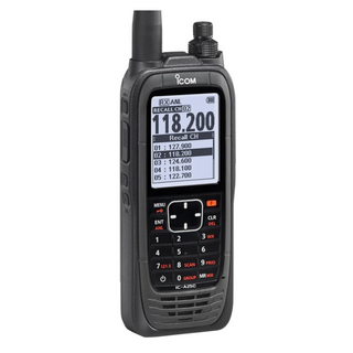

IC-A25CE
$669.95 |
$669.95 | $699.95
In Stock
Order by 3 and your order ships today
SAVE
$15.95
$15.95


MPMA1-B-XXS
$144.00 |
$144.00 | $159.95
Low Stock
Order by 3 and your order ships today
Bestseller
SAVE
$27.95
$27.95


WSHIRT-SS-US04
$52.00 |
$52.00 | $79.95
In Stock
Order by 3 and your order ships today
SAVE
$15.95
$15.95


MPMA1-G-XXS
$144.00 |
$144.00 | $159.95
Low Stock
Order by 3 and your order ships today
Bestseller
SAVE
$24.95
$24.95


8640-L
$225.00 |
$225.00 | $249.95
In Stock
Order by 3 and your order ships today
Pilot's Choice
SAVE
$31
$31

FB3316-C
$119.95 |
$119.95 | $150.95
In Stock
Order by 3 and your order ships today
SAVE
$44.95
$44.95

FLIGHTPATHTV
$5.00 |
$5.00 | $49.95
In Stock
Order by 3 and your order ships today
SAVE
$19.95
$19.95
TGM2200-BL-S
From$36.00 |
From
$36.00 | $55.95
Low Stock
Order by 3 and your order ships today
SAVE
$200
$200


40614
$1,995.00 |
$1,995.00 | $2,195.00
In Stock
Order by 3 and your order ships today
SAVE
$15.95
$15.95


8019946
$90.00 |
$90.00 | $105.95
In Stock
Order by 3 and your order ships today
Everyday
Low Price
Low Price
What' New?
Latest Arrivals


COBI-5764
$109.95
In Stock
Order by 3 and your order ships today
NEW
SAVE
$10
$10


FXHL12RV2GREY
$89.95 |
$89.95 | $99.95
In Stock
Order by 3 and your order ships today
NEW


DP-2
$95.95
In Stock
Order by 3 and your order ships today
NEW


10032
$99.95
In Stock
Order by 3 and your order ships today
NEW


RAM-HOL-AP24-1U
$62.95
In Stock
Order by 3 and your order ships today
NEW


SPORTYS-1726
$49.95
In Stock
Order by 3 and your order ships today
NEW

105-00200
$0.69
In Stock
Order by 3 and your order ships today
NEW


AC6
$109.95
In Stock
Order by 3 and your order ships today
NEW

BA4108
$29.95
In Stock
Order by 3 and your order ships today
NEW

ASPS78A
$52.95
In Stock
Order by 3 and your order ships today
NEW