


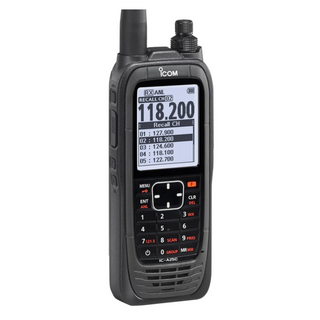
Panel-mounted and portable at the same time!
Even when cockpit-installed, it is always possible to remove the EKP V from the plane to use it with the internal rechargeable battery for updates, flight planning or training school debriefing.
Light and compact
A brilliant 7” display, with removable battery and built-in GPS receiver, with a weight of just 14.1 Oz, covering an area of only 4.3” x 6.8” and only 0,8” thick!
Horizontal or vertical? Fully customizable!
You can choose the Horizontal or Vertical orientation and you can change the layout choosing what to see and where to display it. You can set different aircraft profiles and even configure the F1 hard key.
Advanced Navigation Technology
A comprehensive software, the result of 30 years of Moving Map and Navigation Technology Know-How. Navigation, Electronic Flight Bag, Primary Flight Display: all you need in a single device, developed with safety in mind.
AvMap Software provides advanced planning function, great situational awareness, and useful shortcuts in case of emergency.
Much more than a moving map: a true Multifunctional Display!
Through the Cockpit Docking Station, the EKP V can connect to: AvMap A2 ADAHRS, autopilot, weather receiver, CAS, video camera and other instrument, to create a complete flight information system.
Get Airspeed, Altitude, Attitude and Heading on the EKP V’s 7” display
When connected to the A2 ADAHRS module, the EKP V turns into a full-featured Primary Flight Display providing:
Airspeed and Altitude from Pitot-static system
Attitude, side slip and heading information
Integration of TAWS into the PFD with AGL Altitude indication
Wind indicator with wind components
Clear HSI display linked with EKP V flight planning function
Customizable data fields
PFD settings: Altimeter reference, Heading reference, Aircraft
Specific V-speed reference value.
Advanced Planning
AvMap Software provides advanced planning functions, the result of 30 years of Moving Map and Navigation Technology Know-How.
Maps customization
AvMap maps are made of vector objects, thus it is possible to customize them, selecting which objects to display at every map scale.You can also build three custom map views choosing to highlight different data in each one, and then switch from one view to another with a click of the Cycle button.
You can even import to EKP V your own raster charts!
Situational Awareness & Safety
Navigation, Electronic Flight Bag, Primary Flight Display: all you need in a single device, developed with safety in mind. You can display on the map the HSI or the flight plan vertical profile, while the TAWS colors and the Airspace warning help you stay in cotnrol of the situation.
In case of emergency you can quickly search for the nearest airport and open the geotagged airport diagram and approach plate, and watch the plane icon move on it.
Connection to external instruments
EKP V is much more than a moving map: A true multi-functional display!
Through the smart Cockpit Docking Station, EKP V can connect to: AvMap A2 ADAHRS, autopilot, weather receiver, CAS, video camera and other instruments.
Content Management
With the AvMap Suite, you can manage with ease your EKP V contents: import and export your saved Tracks, Waypoints and Flight Plans. You can import flight plans from these popular flight planning services: RocketRoute, iFlightPlanner and Google Earth.
Hardware
Dimensions 4.3” x 6.8” x 0.8”
Weight 14.1 Oz
Display 7” (16:9) LCD TFT, 64k colors
Display Resolution 800 x 480 pixels
Display Brightness 600 cd/m2
Automatic Brightness Control
Built-in high sensitivity GPS receiver
with WAAS position accuracy
Micro SD preloaded with software and maps
Power supply external 10/35 V DC with cable adapter
Battery lithium-Ion, removable, rechargeable
Consumption max 10 Watt
Speaker
USB OTG master / slave
Temperature range: -20+60° operative / -30°80° storage
Cockpit installation: through optional
Cockpit Cradle Kit or Cockpit docking station
Software
Horizontal / Vertical view
Night Vision
Go to smart menu
(cursor, Airports, VOR, NDB, Intersection, Address, POI, User Point, LAT LON)
Nearest Airport quick search
Set a street address as destination
Electronic flight bag: airport info, diagram and approach plate
Full flight planning capability, up to 15 flight plans of up to 100 legs each
Flight plan page with vertical profile
Vertical Profile on map
Airspace alarm and Flight plan Airspaces check
Full or split HSI / RMI screen with data fields
Full simulator functions
Fully customizable display: choose what to see and where!
Editable checklists to prepare your aircraft for the flight
Customizable profiles for each aircraft with different TAWS settings, map configurations etc.
SAR: Search and Rescue Patterns
Import and export flight plans, waypoints and routes from Navigator to PC
Compatible with the most popular flight planning services: import flight plans from Rocket Route, iFlightplanner and Google Earth
Free Software Updates
Extensions available through Cockpit Docking Station
EFIS: when connected to optional A2 ADAHRS module
Traffic: when connected to optional Collision Avoidance Systems receiver
Video: when connected to optional video camera
Weather info: when connected to optional weather receiver such as XM WX Wxworx (Function Not Available in Australia)
Maps
Jeppesen Database
Street Database by HERE
Airport diagrams
Approach plates
FAA VFR charts ( North America only)
Selective display: select which data to display at every map scale
Map cycles builder: create 3 customized map views choosing objects to be shown
Import your own charts through the AvMap Suite


Customers Also Bought
Product title
Vendor
$19.99 | $24.99
Product title
Vendor
$19.99 | $24.99
Product title
Vendor
$19.99 | $24.99
Product title
Vendor
$19.99 | $24.99

Whats on Sale?
A selection of current specials
$30

$669.95 | $699.95
$15.95


$144.00 | $159.95
$27.95


$52.00 | $79.95
$15.95


$144.00 | $159.95
$24.95


$225.00 | $249.95
$31

$119.95 | $150.95
$44.95

$5.00 | $49.95
$19.95
From
$36.00 | $55.95
$200


$1,995.00 | $2,195.00
$15.95


$90.00 | $105.95
Low Price
What' New?
Latest Arrivals


$109.95
$10


$89.95 | $99.95


$95.95


$99.95


$62.95


$49.95

$0.69


$109.95

$29.95